Dzangal
- Distance: 7.2 mi
- Elevation gain: 2,825 ft
- Maximum elevation: 8,858 ft
- Elevation loss: 2,822 ft
- Minimum elevation: 7,201 ft
- Moving time: 4 h 36 m
- Moving speed: 1.6 mph
- Maximum speed: 4.3 mph
- Total time: 8 h 13 m
- Global speed: 0.9 mph
Interactive map
GPS track profile
About this GPS track
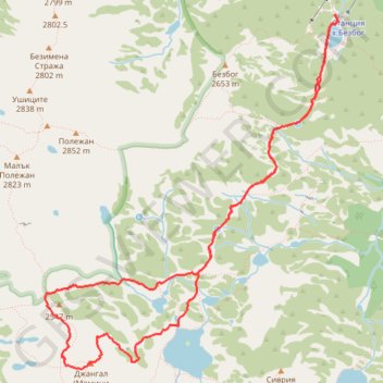
Name: Dzangal GPS track, route, trail
Start: Bansko, Blagoevgrad, Bulgaria (41.73461 23.52415)
End: Bansko, Blagoevgrad, Bulgaria (41.73455 23.52411)
Coordinates: 41.70615 23.49286 41.73461 23.52445
Other GPS tracks
Click on a GPS track to view its route, statistics and profile.
Bezbog hut - Dzhangal (2730) - Popovo ezero - Bezbog hut
Distance: 6.9 mi • Elevation gain: 2,753 ft • Maximum elevation: 8,858 ft
Bezbog Hut - Popovo Lake - Bezbog Hut
Distance: 4.7 mi • Elevation gain: 1,348 ft • Maximum elevation: 7,759 ft
Bezbog Hut - Mt. Polezhan - Mt. Bezbog - Bezbog Hut
Distance: 5.0 mi • Elevation gain: 2,260 ft • Maximum elevation: 9,288 ft