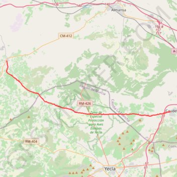
SE05-Caudete-MontealegreDC
Total: 34.6km
- Distance: 21.3 mi
- Elevation gain: 945 ft
- Maximum elevation: 2,628 ft
- Elevation loss: 220 ft
- Minimum elevation: 1,893 ft
Interactive map
GPS track profile
About this GPS track
Name: SE05-Caudete-MontealegreDC GPS track, route, trail
Start: 50, Calle San Juan, Caudete, Albacete, Castille-La Manche, 02660, Espagne (38.70483 -0.99111)
End: Calle Alicante, Montealegre del Castillo, Castille-La Manche, Espagne (38.78629 -1.32765)
Coordinates: 38.69767 -1.32784 38.78629 -0.99111
Other GPS tracks
Click on a GPS track to view route, its statistics and profile.
Southern section — European Divide Trail
France > Auvergne-Rhône-Alpes > Drôme > Valence
Distance: 1,506.1 mi • Elevation gain: 139,026 ft • Maximum elevation: 6,578 ft
1 LUCENA - MONTPELLIER
Distance: 1,842.0 mi • Elevation gain: 96,785 ft • Maximum elevation: 3,438 ft
1 LUCENA - MONTPELLIER
Espagne > Andalousie > Lucena
Distance: 1,842.0 mi • Elevation gain: 96,785 ft • Maximum elevation: 3,438 ft
Stage 26: Valence to Saint-Jean-de-Fos — European Divide Trail
France > Auvergne-Rhône-Alpes > Drôme > Valence
Distance: 1,506.1 mi • Elevation gain: 139,026 ft • Maximum elevation: 6,578 ft
Stage 26: Valence to Saint-Jean-de-Fos — European Divide Trail
France > Auvergne-Rhône-Alpes > Drôme > Valence
Distance: 1,012.7 mi • Elevation gain: 101,184 ft • Maximum elevation: 6,578 ft