SE12-LasMesas-ElToboso
Total: 25.5km
- Distance: 15.8 mi
- Elevation gain: 331 ft
- Maximum elevation: 2,300 ft
- Elevation loss: 295 ft
- Minimum elevation: 2,201 ft
Interactive map
GPS track profile
About this GPS track
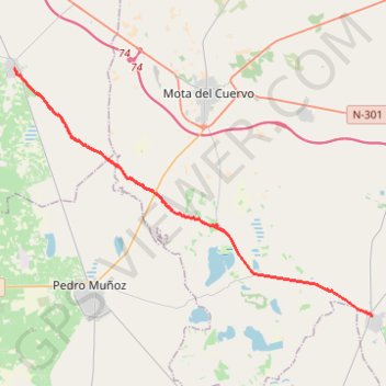
Name: SE12-LasMesas-ElToboso GPS track, route, trail
Start: Calle Las Cruces, Las Mesas, Cuenca, Castille-La Manche, 16650, Espagne (39.39006 -2.76631)
End: Calle María Zambrano, El Toboso, Castille-La Manche, 45820, Espagne (39.51264 -2.99512)
Coordinates: 39.39006 -2.99512 39.51264 -2.76631
Other GPS tracks
Click on a GPS track to view route, its statistics and profile.
EuroVelo 1 (Spain)
Espagne > Andalousie > Côte occidentale > Ayamonte
Distance: 842.4 mi • Elevation gain: 47,858 ft • Maximum elevation: 4,331 ft
Southern section — European Divide Trail
France > Auvergne-Rhône-Alpes > Drôme > Valence
Distance: 1,506.1 mi • Elevation gain: 139,026 ft • Maximum elevation: 6,578 ft
Eurovelo 01 Spain + Portugal
France > Nouvelle-Aquitaine > Pyrénées-Atlantiques > Hendaye
Distance: 1,930.7 mi • Elevation gain: 100,367 ft • Maximum elevation: 4,931 ft
1 LUCENA - MONTPELLIER
Distance: 1,842.0 mi • Elevation gain: 96,785 ft • Maximum elevation: 3,438 ft
1 LUCENA - MONTPELLIER
Espagne > Andalousie > Lucena
Distance: 1,842.0 mi • Elevation gain: 96,785 ft • Maximum elevation: 3,438 ft
Stage 26: Valence to Saint-Jean-de-Fos — European Divide Trail
France > Auvergne-Rhône-Alpes > Drôme > Valence
Distance: 1,506.1 mi • Elevation gain: 139,026 ft • Maximum elevation: 6,578 ft
EuroVelo 1 (Spain)
Espagne > Andalousie > Côte occidentale > Ayamonte > Pozo del Camino > Fotea
Distance: 838.7 mi • Elevation gain: 44,754 ft • Maximum elevation: 4,331 ft
Stage 26: Valence to Saint-Jean-de-Fos — European Divide Trail
France > Auvergne-Rhône-Alpes > Drôme > Valence
Distance: 1,012.7 mi • Elevation gain: 101,184 ft • Maximum elevation: 6,578 ft
SE11-ElProvencio-LasMesas
Espagne > Castille-La Manche > El Provencio
Total: 17.4km
Distance: 10.8 mi • Elevation gain: 92 ft • Maximum elevation: 2,316 ft