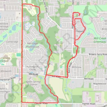
10 Mile Run, Madison AL
Lunch Run
- Distance: 10.2 mi
- Elevation gain: 328 ft
- Maximum elevation: 728 ft
- Elevation loss: 331 ft
- Minimum elevation: 643 ft
- Moving time: 1 h 42 m
- Moving speed: 6.0 mph
- Maximum speed: 9.8 mph
- Total time: 1 h 42 m
- Global speed: 6.0 mph
- Date: 04/21/2024
Interactive map
GPS track profile
About this GPS track
Name: 10 Mile Run, Madison AL GPS track, route, trail
Coordinates: 34.69233 -86.78651 34.72179 -86.76354
Topography: Madison County topographic map
Other GPS tracks
Click on a GPS track to view route, its statistics and profile.
13 Mile Bike, Madison, AL
United States > Alabama > Madison County > Madison
Distance: 13.0 mi • Elevation gain: 420 ft • Maximum elevation: 728 ft
Bicycle-Madison AL
United States > Alabama > Madison County > Madison
Afternoon Ride
Distance: 10.3 mi • Elevation gain: 338 ft • Maximum elevation: 728 ft