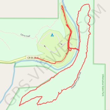
Hike in Villanueva State Park
- Distance: 2.9 mi
- Elevation gain: 479 ft
- Maximum elevation: 6,115 ft
- Elevation loss: 482 ft
- Minimum elevation: 5,745 ft
- Moving time: 1 h 56 m
- Moving speed: 1.5 mph
- Maximum speed: 11.4 mph
- Total time: 5 h 1 m
- Global speed: 0.6 mph
- Date: 04/03/2024
Interactive map
GPS track profile
About this GPS track
Name: Hike in Villanueva State Park GPS track, route, trail
Coordinates: 35.26035 -105.33903 35.26824 -105.33227
Topography: San Miguel County topographic map