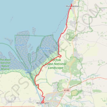
Hunstanton to Kings Lynn
Norfolk Coast Path/England Coast Path
- Distance: 19.4 mi
- Elevation gain: 295 ft
- Maximum elevation: 82 ft
- Elevation loss: 344 ft
- Minimum elevation: -7 ft
- Moving time: 6 h 38 m
- Moving speed: 2.9 mph
- Maximum speed: 9.2 mph
- Total time: 7 h 40 m
- Global speed: 2.5 mph
- Date: 04/06/2024
Interactive map
GPS track profile
About this GPS track
Name: Hunstanton to Kings Lynn GPS track, route, trail
Coordinates: 52.75341 0.37057 52.94325 0.48901