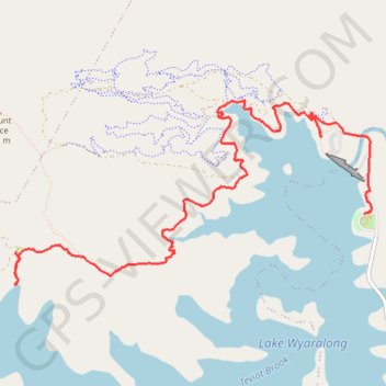
Shoreline trail
Hike / run by the Lake Wyaralong from the dam. #Hike #Run #Lake #Nature #Forest
- Distance: 6.1 mi
- Elevation gain: 869 ft
- Maximum elevation: 518 ft
- Elevation loss: 889 ft
- Minimum elevation: 138 ft
- Moving time: 1 h 21 m
- Moving speed: 4.5 mph
- Maximum speed: 7.5 mph
- Total time: 1 h 30 m
- Global speed: 4.1 mph
- Date: 02/17/2024
Interactive map
GPS track profile
About this GPS track
Name: Shoreline trail GPS track, route, trail
Coordinates: -27.91920 152.84843 -27.90249 152.88512
Other GPS tracks
Click on a GPS track to view route, its statistics and profile.