Import a GPX file

Boy Scout Trail

Hike on Boy Scout Trail through the Joshua Tree National Park. #Hike #Nature #Desert #Rocks #Park

  • Distance: 8.0 mi
  • Elevation gain: 302 ft
  • Maximum elevation: 4,193 ft
  • Elevation loss: 1,483 ft
  • Minimum elevation: 2,854 ft

Interactive map

GPS track profile

About this GPS track
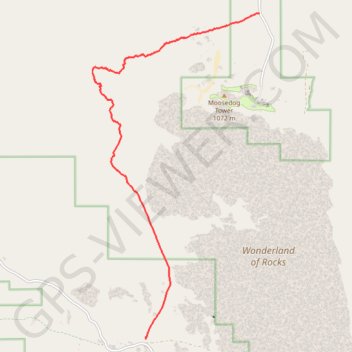
Other GPS tracks

Click on a GPS track to view route, its statistics and profile.

California Riding and Hiking Trail (CRHT)

United States > California > San Bernardino County

Hike on the California Riding and Hiking Trail (CRHT) through the Joshua Tree National Park. #Hike #Nature #Desert #Park #Mountain #CRHT

Distance: 36.4 mi • Elevation gain: 3,094 ft • Maximum elevation: 5,177 ft

Willow Hole

United States > California > San Bernardino County

Hike to Willow Hole by the Boy Scout Trail and the Willow Hole Trail via the Mustang Ranch, the Bear Island and the Wonderland of Rocks in the Joshua Tree National Park. #Hike #Nature #Rocks #Desert #Park

Distance: 3.5 mi • Elevation gain: 200 ft • Maximum elevation: 4,167 ft