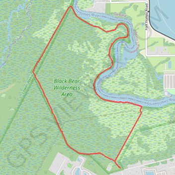
Black Bear Wilderness Loop
Loop hike in the Black Bear Wilderness Area via Black Bear Wilderness Preserve Trail and Saint Johns River. #Hike #Loop #Nature #Forest #River #Wilderness
- Distance: 7.1 mi
- Elevation gain: 62 ft
- Maximum elevation: 23 ft
- Elevation loss: 62 ft
- Minimum elevation: 7 ft
- Moving time: 4 h 46 m
- Moving speed: 1.5 mph
- Maximum speed: 2.9 mph
- Total time: 4 h 57 m
- Global speed: 1.4 mph
- Date: 06/27/2015
Interactive map
GPS track profile
About this GPS track
Name: Black Bear Wilderness Loop GPS track, route, trail
Coordinates: 28.83303 -81.37440 28.86606 -81.34910
Topography: Seminole County topographic map