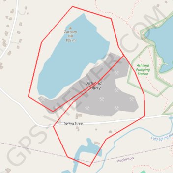
ASP QUARRY
Quarry Route in Ashland
- Distance: 1.8 mi
- Elevation gain: 135 ft
- Maximum elevation: 344 ft
- Elevation loss: 125 ft
- Minimum elevation: 243 ft
Interactive map
GPS track profile
About this GPS track
Name: ASP QUARRY GPS track, route, trail
Coordinates: 42.22930 -71.47933 42.23663 -71.47212
Topography: Middlesex County topographic map
Other GPS tracks
Click on a GPS track to view route, its statistics and profile.
Cambridge - Providence Express
United States > Massachusetts > Middlesex County > Cambridge
Alewife -> Providence
Distance: 63.2 mi • Elevation gain: 3,153 ft • Maximum elevation: 351 ft