NC4K_22_04
- Distance: 166.1 mi
- Elevation gain: 4,386 ft
- Maximum elevation: 295 ft
- Elevation loss: 4,511 ft
- Minimum elevation: -3 ft
Interactive map
GPS track profile
About this GPS track
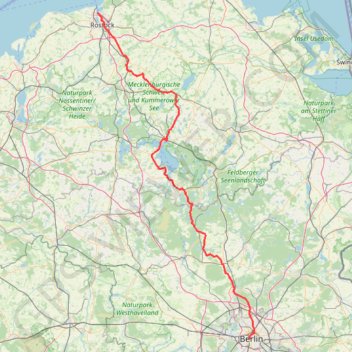
Name: NC4K_22_04 GPS track, route, trail
Start: Pariser Platz, Dorotheenstadt, Mitte, Berlin, 10117, Allemagne (52.51613 13.37803)
Coordinates: 52.51613 12.10181 54.14456 13.41487
Other GPS tracks
Click on a GPS track to view route, its statistics and profile.
NC4K_22_03
Allemagne > Saxe > Vogtlandkreis > Muldenberg
Distance: 196.5 mi • Elevation gain: 6,480 ft • Maximum elevation: 2,379 ft