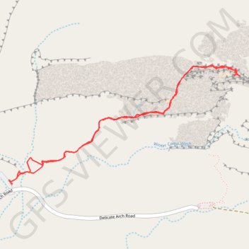
Delicate Arch (Arches National Park)
Hike to Delicate Arch via Delicate Arch Trail in the Arches National Park. #Hike #Nature #Rock #Park
- Distance: 3.4 mi
- Elevation gain: 771 ft
- Maximum elevation: 4,820 ft
- Elevation loss: 768 ft
- Minimum elevation: 4,291 ft
- Moving time: 1 h 25 m
- Moving speed: 2.4 mph
- Maximum speed: 4.1 mph
- Total time: 1 h 48 m
- Global speed: 1.9 mph
- Date: 03/01/2016
Interactive map
GPS track profile
About this GPS track
Name: Delicate Arch (Arches National Park) GPS track, route, trail
Start: Delicate Arch Trail, Grand County, Utah, United States (38.73554 -109.52034)
End: Delicate Arch Trail, Grand County, Utah, United States (38.73606 -109.51985)
Coordinates: 38.73553 -109.52065 38.74431 -109.49881
Topography: Grand County topographic map
Other GPS tracks
Click on a GPS track to view route, its statistics and profile.