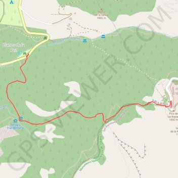
Trail Planner Map
- Distance: 2.9 mi
- Elevation gain: 909 ft
- Maximum elevation: 6,365 ft
- Elevation loss: 909 ft
- Minimum elevation: 5,479 ft
Interactive map
GPS track profile
About this GPS track
Name: Trail Planner Map GPS track, route, trail
Start: GC-600, Llanos de la Pez, Tejeda, Las Palmas, Îles Canaries, 35360, Espagne (27.96607 -15.58377)
End: GC-600, Llanos de la Pez, Tejeda, Las Palmas, Îles Canaries, 35360, Espagne (27.96607 -15.58377)
Coordinates: 27.96092 -15.58555 27.96607 -15.57195
Other GPS tracks
Click on a GPS track to view route, its statistics and profile.
TGCC 2024 10.07.2023
Espagne > Las Palmas de Grande Canarie
Distance: 79.6 mi • Elevation gain: 23,612 ft • Maximum elevation: 5,728 ft
Llanos de la Pez - Pico de las Nieves - Degollada de los Hornos
Distance: 4.2 mi • Elevation gain: 1,145 ft • Maximum elevation: 6,342 ft