Norvège - Alpes de Lyngen - Ullstinden
Ski. En aller simple. #Ski
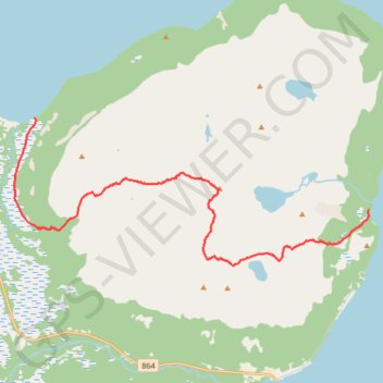
- Distance: 7.5 mi
- Elevation gain: 3,494 ft
- Maximum elevation: 3,504 ft
- Elevation loss: 3,497 ft
- Minimum elevation: 3 ft
- Moving time: 3 h 17 m
- Moving speed: 2.3 mph
- Maximum speed: 19.4 mph
- Total time: 5 h 11 m
- Global speed: 1.4 mph
- Date: 03/17/2012
Interactive map
GPS track profile
About this GPS track
Name: Norvège - Alpes de Lyngen - Ullstinden GPS track, route, trail
Start: Piksteinen, Ullstindvegen, Lyngnes, Tromsø, Troms og Finnmark, Norvège (69.79725 19.56832)
End: 375, Skotsætvegen, Skotsætet - Čievra, Tromsø, Troms og Finnmark, 9034, Norvège (69.78301 19.71707)
Coordinates: 69.77445 19.55921 69.79725 19.71716
Other GPS tracks
Click on a GPS track to view route, its statistics and profile.
Stage 1: Arctic Ocean to Väylä — European Divide Trail
Distance: 1,730.5 mi • Elevation gain: 78,159 ft • Maximum elevation: 2,369 ft