Stokkvika north and south bank
- Distance: 8.2 mi
- Elevation gain: 3,169 ft
- Maximum elevation: 1,352 ft
- Elevation loss: 3,123 ft
- Minimum elevation: 7 ft
Interactive map
GPS track profile
About this GPS track
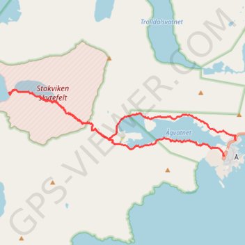
Name: Stokkvika north and south bank GPS track, route, trail
Start: 1270, Moskenesveien, Å-gården, Sørvågen, Moskenes, Nordland, 8392, Norvège (67.88277 12.98383)
End: E 10, Å-gården, Å, Moskenes, Nordland, 8392, Norvège (67.87979 12.97768)
Coordinates: 67.87979 12.86401 67.89289 12.98383
Other GPS tracks
Click on a GPS track to view route, its statistics and profile.
Stage 1: Arctic Ocean to Väylä — European Divide Trail
Distance: 1,730.5 mi • Elevation gain: 78,159 ft • Maximum elevation: 2,369 ft
Munkebu-Hermannsdalstinden-Moskenes
Randonnée pédestre. #Randonnée
Distance: 9.8 mi • Elevation gain: 4,944 ft • Maximum elevation: 3,376 ft
GT_Moskenesoya_Etape10
Distance: 8.3 mi • Elevation gain: 2,602 ft • Maximum elevation: 2,484 ft
GT_Moskenesoya_Etape11
Distance: 7.8 mi • Elevation gain: 3,091 ft • Maximum elevation: 1,352 ft