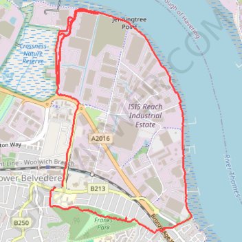
Erith Thames Path
Loop hike via Crossness Nature Reserve, River Thames and Frank's Park. #Hike #Loop #Nature #City #River #Park #Forest
- Distance: 5.2 mi
- Elevation gain: 197 ft
- Maximum elevation: 95 ft
- Elevation loss: 200 ft
- Minimum elevation: 0 ft
- Moving time: 1 h 40 m
- Moving speed: 3.1 mph
- Maximum speed: 5.7 mph
- Total time: 1 h 41 m
- Global speed: 3.1 mph
- Date: 02/11/2024
Interactive map
GPS track profile
About this GPS track
Name: Erith Thames Path GPS track, route, trail
Coordinates: 51.48665 0.15372 51.50567 0.17312
Other GPS tracks
Click on a GPS track to view route, its statistics and profile.
Erith Marshes
United Kingdom > England > London
Morning Walk
Distance: 5.6 mi • Elevation gain: 348 ft • Maximum elevation: 240 ft
Newhaven Londres
Royaume-Uni > Angleterre > Cité de Londres
Vélo. En aller simple entre Londres et Newhaven. #Vélo
Distance: 96.7 mi • Elevation gain: 3,737 ft • Maximum elevation: 663 ft