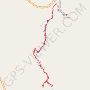
Notch trail
Hike along the Notch Creek on the Notch trail in the Badlands National Park. #Hike #Nature #Park
- Distance: 1.4 mi
- Elevation gain: 171 ft
- Maximum elevation: 2,799 ft
- Elevation loss: 171 ft
- Minimum elevation: 2,644 ft
- Moving time: 49 m 1 s
- Moving speed: 1.8 mph
- Maximum speed: 4.0 mph
- Total time: 1 h 11 m
- Global speed: 1.2 mph
- Date: 08/10/2023
Interactive map
GPS track profile
About this GPS track
Name: Notch trail GPS track, route, trail
Start: Notch Trail, Jackson County, South Dakota, 57750, United States (43.76007 -101.92824)
Coordinates: 43.75297 -101.93072 43.76029 -101.92796
Topography: Jackson County topographic map