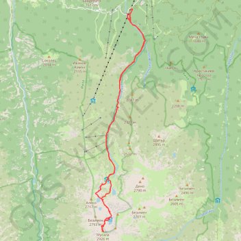
Musala peak, the highest of Bulgaria (and the whole Balkan)
- Distance: 15.9 mi
- Elevation gain: 5,112 ft
- Maximum elevation: 9,583 ft
- Elevation loss: 5,112 ft
- Minimum elevation: 4,626 ft
Interactive map
GPS track profile
About this GPS track
Name: Musala peak, the highest of Bulgaria (and the whole Balkan) GPS track, route, trail
Start: SFO1570, Borovets, Samokov, Sofia, 2010, Bulgaria (42.25689 23.59721)
End: SFO1570, Borovets, Samokov, Sofia, 2010, Bulgaria (42.25691 23.59718)
Coordinates: 42.17874 23.58169 42.25868 23.60595
Topography: Sofia topographic map