Segment 1-500
- Distance: 10.0 mi
- Elevation gain: 879 ft
- Maximum elevation: 1,027 ft
- Elevation loss: 600 ft
- Minimum elevation: 686 ft
Interactive map
GPS track profile
About this GPS track
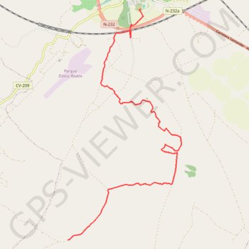
Name: Segment 1-500 GPS track, route, trail
End: Acampos, Fuentes de Ebro, Zaragoza, Saragosse, Aragon, Espagne (41.43354 -0.65477)
Coordinates: 41.43351 -0.65477 41.50507 -0.60785
Other GPS tracks
Click on a GPS track to view route, its statistics and profile.
Southern section — European Divide Trail
France > Auvergne-Rhône-Alpes > Drôme > Valence
Distance: 1,506.1 mi • Elevation gain: 139,026 ft • Maximum elevation: 6,578 ft
1 LUCENA - MONTPELLIER
Distance: 1,842.0 mi • Elevation gain: 96,785 ft • Maximum elevation: 3,438 ft
1 LUCENA - MONTPELLIER
Espagne > Andalousie > Lucena
Distance: 1,842.0 mi • Elevation gain: 96,785 ft • Maximum elevation: 3,438 ft
Stage 26: Valence to Saint-Jean-de-Fos — European Divide Trail
France > Auvergne-Rhône-Alpes > Drôme > Valence
Distance: 1,506.1 mi • Elevation gain: 139,026 ft • Maximum elevation: 6,578 ft
Stage 26: Valence to Saint-Jean-de-Fos — European Divide Trail
France > Auvergne-Rhône-Alpes > Drôme > Valence
Distance: 1,012.7 mi • Elevation gain: 101,184 ft • Maximum elevation: 6,578 ft
De Villeneuve-sur-Lot à Guimarães
France > Nouvelle-Aquitaine > Lot-et-Garonne > Villeneuve-sur-Lot
Distance: 1,257.8 mi • Elevation gain: 72,575 ft • Maximum elevation: 4,393 ft