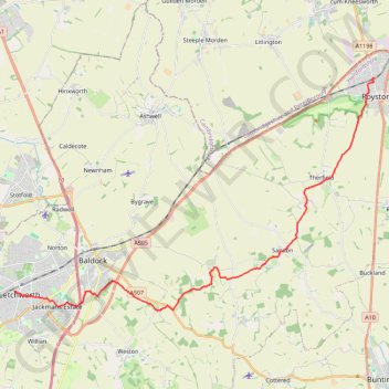
From Royston to Letchworth
- Distance: 14.7 mi
- Elevation gain: 853 ft
- Maximum elevation: 551 ft
- Elevation loss: 768 ft
- Minimum elevation: 190 ft
- Moving time: 5 h 34 m
- Moving speed: 2.6 mph
- Maximum speed: 3.7 mph
- Total time: 6 h 20 m
- Global speed: 2.3 mph
- Date: 03/30/2023
Interactive map
GPS track profile
About this GPS track
Name: From Royston to Letchworth GPS track, route, trail
Coordinates: 51.97090 -0.23335 52.05355 -0.02562
Other GPS tracks
Click on a GPS track to view route, its statistics and profile.
Circuit from Baldock
United Kingdom > England > Hertfordshire > North Hertfordshire > Baldock
Distance: 12.6 mi • Elevation gain: 663 ft • Maximum elevation: 489 ft
Deacon Hill
United Kingdom > England > Hertfordshire > North Hertfordshire
Letchworth, Ickleford, Pirton, Deacon Hill and return
Distance: 16.4 mi • Elevation gain: 961 ft • Maximum elevation: 597 ft