Slalom agon
slalom agon
- Distance: 0.7 mi
- Elevation gain: 16 ft
- Maximum elevation: 26 ft
- Elevation loss: 13 ft
- Minimum elevation: 16 ft
Interactive map
GPS track profile
About this GPS track
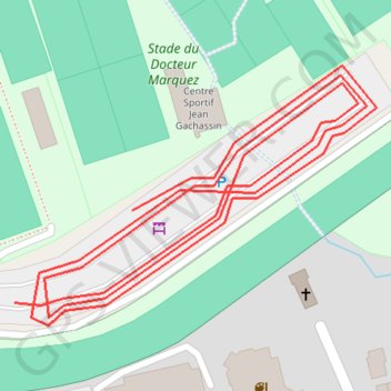
Name: Slalom agon GPS track, route, trail
Coordinates: 49.04913 -1.59741 49.05017 -1.59520
Other GPS tracks
Click on a GPS track to view route, its statistics and profile.
GR 223 Tour du Cotentin (2021)
France > Normandie > Eure > Berville-sur-Mer
Randonnée en Normandie sur le GR 223 autour du Cotentin à travers l'Eure, le Calvados et la Manche de Berville-sur-Mer au Mont-Saint-Michel.
Distance: 404.3 mi • Elevation gain: 21,932 ft • Maximum elevation: 489 ft
Sentier Cotentin - Cherbourg vers Mont-Saint-Michel
France > Normandie > Manche > La Hague > Urville-Nacqueville > La Rivière
Distance: 144.0 mi • Elevation gain: 8,478 ft • Maximum elevation: 420 ft
HexaTrekGPX
France > Nouvelle-Aquitaine > Pyrénées-Atlantiques > Hendaye
Distance: 1,670.4 mi • Elevation gain: 452,047 ft • Maximum elevation: 9,675 ft
3 Sainte-Mère Hauteville
France > Normandie > Manche > Sainte-Mère-Église > Richedoux
Parcours initial Sainte-Mère Hauteville le 07/06/2024 à 16H30
Distance: 51.1 mi • Elevation gain: 1,253 ft • Maximum elevation: 180 ft
Tour d'Europe
France > Bretagne > Finistère > Concarneau > Landan Creis
Distance: 4,432.2 mi • Elevation gain: 146,335 ft • Maximum elevation: 7,982 ft
GR223 - Cherbourg à Coutances
France > Normandie > Manche > Cherbourg-en-Cotentin
Randonnée entre Cherbourg-Octeville et Coutances. #Randonnée
Distance: 125.1 mi • Elevation gain: 6,909 ft • Maximum elevation: 453 ft
RAF 2022 / 2600 n1 News
France > Hauts-de-France > Pas-de-Calais > Le Touquet-Paris-Plage
Distance: 1,612.3 mi • Elevation gain: 130,331 ft • Maximum elevation: 9,075 ft
Itinéraire de Nemours à Nemours
France > Centre-Val de Loire > Loiret > Bromeilles > Bainvilliers
Distance: 979.5 mi • Elevation gain: 28,005 ft • Maximum elevation: 781 ft
TM2024 ET2 Barneville- Sartilly V1-17625469
France > Normandie > Manche > Barneville-Carteret > Le Dessous du Bourg
Distance: 106.1 mi • Elevation gain: 5,656 ft • Maximum elevation: 427 ft
Carentan (50500), Carentan-les-Marais, Manche, Normandie, France - Caen (14000), Calvados, Normandie, France
France > Normandie > Manche > Carentan-les-Marais
Distance: 229.0 mi • Elevation gain: 11,299 ft • Maximum elevation: 863 ft
Hexatrek_Parcours_Complet_NOBO
France > Nouvelle-Aquitaine > Pyrénées-Atlantiques > Hendaye
Distance: 1,669.6 mi • Elevation gain: 454,554 ft • Maximum elevation: 9,259 ft
1 - etape-3-tdn-2024-parcours (1)
France > Normandie > Manche > Coutances
Etape 3 16 mars 2024
Distance: 85.2 mi • Elevation gain: 6,007 ft • Maximum elevation: 515 ft
Track-Saint Jean de Luz
Belgique > Hainaut > Ath > Lessines
Distance: 740.9 mi • Elevation gain: 31,145 ft • Maximum elevation: 1,594 ft
Track-Saint de Luz retour
France > Nouvelle-Aquitaine > Pyrénées-Atlantiques > Saint-Jean-de-Luz
Distance: 704.3 mi • Elevation gain: 22,598 ft • Maximum elevation: 843 ft
Hexatrek_Parcours_Complet_SOBO
Allemagne > Rhénanie-Palatinat > Arrondissement de la Route-du-Vin-du-Sud > Schweigen-Rechtenbach
Distance: 1,670.4 mi • Elevation gain: 454,117 ft • Maximum elevation: 9,278 ft
TM2024 ET2 Barneville- Sartilly V1-17625469
France > Normandie > Manche > Barneville-Carteret > Le Dessous du Bourg
Distance: 106.1 mi • Elevation gain: 5,656 ft • Maximum elevation: 427 ft
TM2024 ET2 Barneville - Sartilly V2-17230687
France > Normandie > Manche > Barneville-Carteret > Le Dessous du Bourg
Distance: 98.3 mi • Elevation gain: 4,977 ft • Maximum elevation: 427 ft
Boucle de 31 km commune
France > Normandie > Manche > Coutainville
boucle commune a tous les points, traversée R650 au niveau des serres pas possible dans votre logiciel
Distance: 23.0 mi • Elevation gain: 699 ft • Maximum elevation: 190 ft
HexaTrekGPX
France > Nouvelle-Aquitaine > Pyrénées-Atlantiques > Hendaye
Distance: 1,670.4 mi • Elevation gain: 452,047 ft • Maximum elevation: 9,675 ft
TM2024 ET2 Barneville - Sartilly V2-17230687
France > Normandie > Manche > Barneville-Carteret > Le Dessous du Bourg
Distance: 107.7 mi • Elevation gain: 5,279 ft • Maximum elevation: 427 ft
TM2024 ET2 Barneville - Sartilly V2-17230687
France > Normandie > Manche > Barneville-Carteret > Le Dessous du Bourg
Distance: 105.9 mi • Elevation gain: 5,098 ft • Maximum elevation: 427 ft
TM2024 ET2 Barneville - Sartilly V2-17230687
France > Normandie > Manche > Barneville-Carteret > Le Dessous du Bourg
Distance: 99.3 mi • Elevation gain: 4,987 ft • Maximum elevation: 427 ft
TM2024 ET2 Barneville - Sartilly V2-17230687
France > Normandie > Manche > Barneville-Carteret > Le Dessous du Bourg
Distance: 99.3 mi • Elevation gain: 4,987 ft • Maximum elevation: 427 ft
TM2023 Etape 3 SARTILLY - LA HAYE
France > Normandie > Manche > Sartilly-Baie-Bocage
Distance: 61.9 mi • Elevation gain: 2,549 ft • Maximum elevation: 433 ft
TM2023 Etape 3 SARTILLY - LA HAYE-15747753
France > Normandie > Manche > Sartilly-Baie-Bocage
Distance: 61.9 mi • Elevation gain: 2,549 ft • Maximum elevation: 433 ft
TM2023 ET3 Sartilly - La Haye Evite RD57-16675356
France > Normandie > Manche > Sartilly-Baie-Bocage
Distance: 61.6 mi • Elevation gain: 2,244 ft • Maximum elevation: 417 ft
TM2023 Etape 3 SARTILLY - LA HAYE V4-15747753
France > Normandie > Manche > Sartilly-Baie-Bocage
Distance: 61.8 mi • Elevation gain: 2,234 ft • Maximum elevation: 433 ft
TM2023 Etape 3 SARTILLY - LA HAYE V4-15747753
France > Normandie > Manche > Sartilly-Baie-Bocage
Distance: 62.1 mi • Elevation gain: 2,264 ft • Maximum elevation: 433 ft
Granv-Lingr-Car 78k
France > Normandie > Manche > Granville
Distance: 48.5 mi • Elevation gain: 2,005 ft • Maximum elevation: 472 ft
TM2023 SARTILLY - LA HAYE-15747753
France > Normandie > Manche > Sartilly-Baie-Bocage > L'Anquetillière
Distance: 60.7 mi • Elevation gain: 2,316 ft • Maximum elevation: 433 ft
TM2023 SARTILLY - LA HAYE-15747753
France > Normandie > Manche > Sartilly-Baie-Bocage > L'Anquetillière
Distance: 60.7 mi • Elevation gain: 2,316 ft • Maximum elevation: 433 ft
TM2023 Sartilly- LaHaye V2-15747753
France > Normandie > Manche > Sartilly-Baie-Bocage > L'Anquetillière
Distance: 61.4 mi • Elevation gain: 2,333 ft • Maximum elevation: 433 ft
TM2023 Sartilly- LaHaye V2-15747753
France > Normandie > Manche > Sartilly-Baie-Bocage > L'Anquetillière
Distance: 61.4 mi • Elevation gain: 2,333 ft • Maximum elevation: 433 ft
ETAPE 02 Barneville /Torigni V2
France > Normandie > Manche > Barneville-Carteret > Le Dessous du Bourg
Distance: 103.7 mi • Elevation gain: 4,711 ft • Maximum elevation: 696 ft
ETAPE 02 Barneville /Torigni V2
France > Normandie > Manche > Barneville-Carteret > Le Dessous du Bourg
Distance: 103.7 mi • Elevation gain: 4,711 ft • Maximum elevation: 696 ft
ETAPE 01 _V4 Yquelon/Barneville
France > Normandie > Manche > Yquelon
Distance: 86.1 mi • Elevation gain: 3,307 ft • Maximum elevation: 341 ft
ETAPE 02 Barneville /Torigni
France > Normandie > Manche > Barneville-Carteret > Le Dessous du Bourg
Distance: 87.1 mi • Elevation gain: 3,714 ft • Maximum elevation: 686 ft
ETAPE 02 Barneville /Torigni
France > Normandie > Manche > Barneville-Carteret > Le Dessous du Bourg
Distance: 88.1 mi • Elevation gain: 3,839 ft • Maximum elevation: 686 ft
ETAPE 01 _V4 Yquelon/Barneville
France > Normandie > Manche > Yquelon
Distance: 86.1 mi • Elevation gain: 3,307 ft • Maximum elevation: 341 ft
ETAPE 01 _V3 Yquelon/Barneville
France > Normandie > Manche > Yquelon
Distance: 86.1 mi • Elevation gain: 3,310 ft • Maximum elevation: 341 ft
Yquelon_Barneville_V3
France > Normandie > Manche > Yquelon
Distance: 100.8 mi • Elevation gain: 4,108 ft • Maximum elevation: 341 ft
ETAPE 01 Yquelon/Barneville
France > Normandie > Manche > Yquelon
Distance: 89.9 mi • Elevation gain: 3,753 ft • Maximum elevation: 440 ft