打石石澗
Outdoor hiking
- Distance: 0.8 mi
- Elevation gain: 489 ft
- Maximum elevation: 669 ft
- Elevation loss: 256 ft
- Minimum elevation: 177 ft
- Moving time: 26 m 15 s
- Moving speed: 1.9 mph
- Maximum speed: 3.4 mph
- Total time: 3 h 21 m
- Global speed: 0.2 mph
- Date: 04/03/2024
Interactive map
GPS track profile
About this GPS track
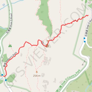
Name: 打石石澗 GPS track, route, trail
Start: Shek O Road, Shek O, Southern District, Hong Kong Island, Hong Kong, China (22.23187 114.24694)
Coordinates: 22.22704 114.23970 22.23187 114.24694
Other GPS tracks
Click on a GPS track to view route, its statistics and profile.
Hong Kong island ride
China > Hong Kong > Hong Kong Island
#Bike
Distance: 38.4 mi • Elevation gain: 7,060 ft • Maximum elevation: 1,657 ft
Wilson Trail Full Route
China > Hong Kong > Hong Kong Island
Distance: 50.5 mi • Elevation gain: 14,534 ft • Maximum elevation: 2,011 ft