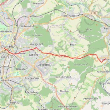
Biking#4
- Distance: 8.1 mi
- Elevation gain: 810 ft
- Maximum elevation: 1,532 ft
- Elevation loss: 814 ft
- Minimum elevation: 984 ft
- Moving time: 42 m 2 s
- Moving speed: 11.5 mph
- Maximum speed: 34.4 mph
- Total time: 42 m 2 s
- Global speed: 11.5 mph
- Date: 09/19/2021
Interactive map
GPS track profile
About this GPS track
Name: Biking#4 GPS track, route, trail
End: 8, Hohe Straße, Kaßberg, Chemnitz, Saxony, 09112, Germany (50.83061 12.91345)
Coordinates: 50.81640 12.91345 50.83099 13.07477
Other GPS tracks
Click on a GPS track to view route, its statistics and profile.
Tour d'Europe
France > Bretagne > Finistère > Concarneau > Landan Creis
Distance: 4,432.2 mi • Elevation gain: 146,335 ft • Maximum elevation: 7,982 ft
Marche-en-Famenne
Belgique > Luxembourg > Marche-en-Famenne > Marche-en-Famenne
<p>From Rue Dupont 46, 6900 Marche-en-Famenne, Belgium<br/> To Avenue de France, 6900 Marche-en-Famenne, Belgium</p> <p>Routing Motor - nicest</p>
Distance: 1,766.8 mi • Elevation gain: 94,672 ft • Maximum elevation: 3,537 ft
NC4K_22_03
Allemagne > Saxe > Vogtlandkreis > Muldenberg
Distance: 196.5 mi • Elevation gain: 6,480 ft • Maximum elevation: 2,379 ft