Velez/competa (por Torrox y casa de la mina)
- Distance: 39.8 mi
- Elevation gain: 6,388 ft
- Maximum elevation: 3,120 ft
- Elevation loss: 6,385 ft
- Minimum elevation: 3 ft
- Moving time: 3 h 56 m
- Moving speed: 10.1 mph
- Maximum speed: 35.1 mph
- Total time: 4 h 43 m
- Global speed: 8.4 mph
- Date: 12/24/2020
Interactive map
GPS track profile
About this GPS track
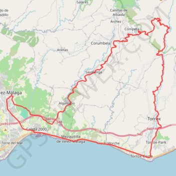
Name: Velez/competa (por Torrox y casa de la mina) GPS track, route, trail
Coordinates: 36.72943 -4.10027 36.84145 -3.93717
Other GPS tracks
Click on a GPS track to view route, its statistics and profile.
Southern Section — European Divide Trail
Espagne > Andalousie > Cazorla
Distance: 516.0 mi • Elevation gain: 63,166 ft • Maximum elevation: 7,001 ft
Vila do Bispo -> Distrito 4 (495,2 km)
Distance: 811.8 mi • Elevation gain: 75,879 ft • Maximum elevation: 7,001 ft
Torre del Mar - La Buitrera
Espagne > Andalousie > La Axarquía > Vélez-Málaga > Torre del Mar
Distance: 32.4 mi • Elevation gain: 5,302 ft • Maximum elevation: 2,657 ft
Velez/Buitrera de sedella/pasada granadillos/velez
Espagne > Andalousie > La Axarquía > Vélez-Málaga
Distance: 29.1 mi • Elevation gain: 6,181 ft • Maximum elevation: 2,986 ft
Vélez-Málaga-Arenas-Daimalos-Corumbela-Árchez-Sayalonga-Alga...
Espagne > Andalousie > La Axarquía > Vélez-Málaga
Distance: 28.5 mi • Elevation gain: 4,085 ft • Maximum elevation: 1,975 ft
Cortijo hasta Sedella y vuelta.
Espagne > Andalousie > La Axarquía > Algarrobo-Costa
Distance: 34.0 mi • Elevation gain: 7,802 ft • Maximum elevation: 2,612 ft