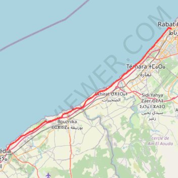
20210912 sortie 120km.gpx
- Distance: 74.9 mi
- Elevation gain: 2,070 ft
- Maximum elevation: 118 ft
- Elevation loss: 2,073 ft
- Minimum elevation: 3 ft
- Moving time: 5 h 23 m
- Moving speed: 13.9 mph
- Maximum speed: 23.1 mph
- Total time: 5 h 40 m
- Global speed: 13.2 mph
- Date: 09/12/2021
Interactive map
GPS track profile
About this GPS track
Name: 20210912 sortie 120km.gpx GPS track, route, trail
Coordinates: 33.71565 -7.34275 34.02265 -6.84593
Other GPS tracks
Click on a GPS track to view route, its statistics and profile.
Maroc en boucle depuis Tanger
Maroc > pachalik de Tanger > Tanger
Distance: 1,882.0 mi • Elevation gain: 89,413 ft • Maximum elevation: 7,549 ft
Marruecos Junio 2019. De Berguent a Esmara
Maroc > Pachalik de Ain Bni Mathar > Ain Bni Mathar
Distance: 1,411.5 mi • Elevation gain: 38,770 ft • Maximum elevation: 4,770 ft