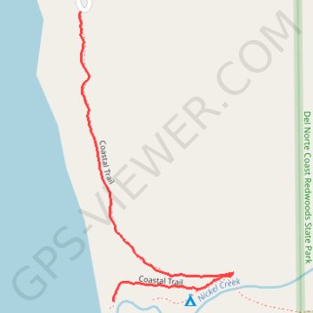
Coastal Trail
- Distance: 0.7 mi
- Elevation gain: 197 ft
- Maximum elevation: 190 ft
- Elevation loss: 36 ft
- Minimum elevation: 23 ft
- Moving time: 15 m 7 s
- Moving speed: 2.6 mph
- Maximum speed: 3.9 mph
- Total time: 17 m 30 s
- Global speed: 2.3 mph
- Date: 06/07/2024
Interactive map
GPS track profile
About this GPS track
Name: Coastal Trail GPS track, route, trail
Start: Coastal Trail, Del Norte County, California, United States (41.70029 -124.14193)
End: Coastal Trail, Del Norte County, California, United States (41.70562 -124.14274)
Coordinates: 41.70029 -124.14278 41.70562 -124.13898
Topography: Del Norte County topographic map
Other GPS tracks
Click on a GPS track to view route, its statistics and profile.
Coastal Trail and Beach
United States > California > Del Norte County
Distance: 1.5 mi • Elevation gain: 128 ft • Maximum elevation: 194 ft