Cinder Cone Trail
- Distance: 4.7 mi
- Elevation gain: 1,070 ft
- Maximum elevation: 6,834 ft
- Elevation loss: 1,070 ft
- Minimum elevation: 6,093 ft
Interactive map
GPS track profile
About this GPS track
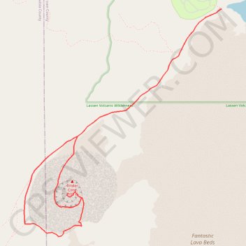
Name: Cinder Cone Trail GPS track, route, trail
Start: Butte Lake To Snag Lake Trail, Lassen County, California, United States (40.56385 -121.30210)
End: Butte Lake To Snag Lake Trail, Lassen County, California, United States (40.56385 -121.30209)
Coordinates: 40.54358 -121.32527 40.56385 -121.30209
Topography: Lassen County topographic map
Other GPS tracks
Click on a GPS track to view route, its statistics and profile.
Ashland - Chester
États-Unis d'Amérique > Oregon > Jackson County > Ashland
Vélo. En aller simple entre Ashland et Chester. #Vélo
Distance: 252.7 mi • Elevation gain: 18,691 ft • Maximum elevation: 8,533 ft