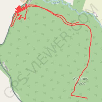
RE SO320930
- Distance: 1.8 mi
- Elevation gain: 371 ft
- Maximum elevation: 758 ft
- Elevation loss: 436 ft
- Minimum elevation: 673 ft
Interactive map
GPS track profile
About this GPS track
Name: RE SO320930 GPS track, route, trail
Start: Owl's Lane, Owlbury, Lydham, Shropshire, England, SY9 5HQ, United Kingdom (52.52681 -2.99746)
End: Hyssington, More, Shropshire, England, SY9 5GB, United Kingdom (52.53054 -2.99812)
Coordinates: 52.52681 -3.00365 52.53145 -2.99713
Other GPS tracks
Click on a GPS track to view route, its statistics and profile.
Bridges to Bishops Castle
United Kingdom > England > Shropshire > Bridges
Distance: 11.7 mi • Elevation gain: 1,798 ft • Maximum elevation: 1,729 ft
TT22 J9 M7/06 : Heysham Port à Aberystwyth
Royaume-Uni > Angleterre > Lancashire > Lancaster > Morecambe
Distance: 215.9 mi • Elevation gain: 13,264 ft • Maximum elevation: 1,375 ft