Tías VTT
- Distance: 40.9 mi
- Elevation gain: 3,350 ft
- Maximum elevation: 1,122 ft
- Elevation loss: 3,353 ft
- Minimum elevation: 0 ft
- Moving time: 6 h 48 s
- Moving speed: 6.8 mph
- Maximum speed: 22.5 mph
- Total time: 8 h 43 m
- Global speed: 4.7 mph
- Date: 03/11/2023
Interactive map
GPS track profile
About this GPS track
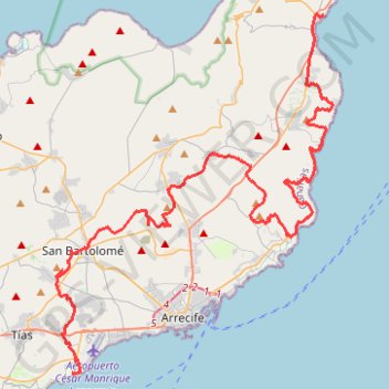
Name: Tías VTT GPS track, route, trail
Start: Gramillo, Matagorda, Tías, Las Palmas, Îles Canaries, 35519, Espagne (28.93188 -13.62030)
End: Calle El Charcon, Arrieta, Haría, Las Palmas, Îles Canaries, 35542, Espagne (29.13262 -13.45978)
Coordinates: 28.93159 -13.63090 29.13331 -13.45358