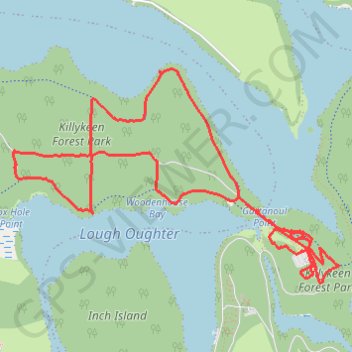
Killykeen Forest Park
Loop hike through Killykeen Forest by the Lough Oughter from Derinish Beg via Killykeen Greenway. #Hike #Loop #Nature #Forest #Park #Lake
- Distance: 4.6 mi
- Elevation gain: 312 ft
- Maximum elevation: 223 ft
- Elevation loss: 305 ft
- Minimum elevation: 151 ft
- Moving time: 1 h 30 m
- Moving speed: 3.1 mph
- Maximum speed: 8.2 mph
- Total time: 1 h 33 m
- Global speed: 3.0 mph
- Date: 02/10/2024
Interactive map
GPS track profile
About this GPS track
Name: Killykeen Forest Park GPS track, route, trail
Coordinates: 54.00448 -7.49225 54.01533 -7.46404
Other GPS tracks
Click on a GPS track to view route, its statistics and profile.
RT5-1 Rosslare - Kinsale
Distance: 1,777.3 mi • Elevation gain: 89,833 ft • Maximum elevation: 1,378 ft
RT5-1 Rosslare - Kinsale
Distance: 2,402.9 mi • Elevation gain: 118,488 ft • Maximum elevation: 1,719 ft