The Wave
Hike to The Wave via Wire Pass and Plateau Rock in Coyote Buttes North and the Paria Canyon-Vermilion Cliffs Wilderness. #Hike #Nature #Rock #Wilderness
- Distance: 2.8 mi
- Elevation gain: 699 ft
- Maximum elevation: 5,233 ft
- Elevation loss: 341 ft
- Minimum elevation: 4,829 ft
- Moving time: 2 h 52 m
- Moving speed: 1.0 mph
- Maximum speed: 1.8 mph
- Total time: 4 h 10 m
- Global speed: 0.7 mph
- Date: 02/20/2024
Interactive map
GPS track profile
About this GPS track
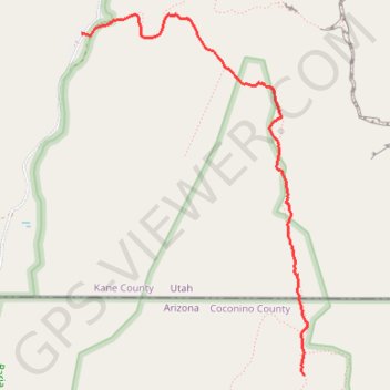
Name: The Wave GPS track, route, trail
Start: Wire Pass Trail, Utah, United States (37.01903 -112.02506)
End: The Loop, Coconino County, Arizona, United States (36.99572 -112.00603)
Coordinates: 36.99572 -112.02506 37.02037 -112.00573
Topography: Utah topographic map
Other GPS tracks
Click on a GPS track to view route, its statistics and profile.
Buckskin Gulch
Hike from Wire Pass Trailhead to Buckskin Gulch via Wire Pass Trail, Wire Pass Slot Canyon, Buckskin Gulch Trail, Buckskin Overlook and Upper Buckskin Gulch Trail in the Grand Staircase-Escalante National Monument and the Paria Canyon-Vermilion Cliffs Wilderness. #Hike #Nature #Canyon #Desert #Overlook #Wilderness
Distance: 10.3 mi • Elevation gain: 1,250 ft • Maximum elevation: 4,875 ft