Winchcombe
Loop hike from Winchcombe. #Hike #Loop #Nature #Countryside #River #Forest
- Distance: 6.3 mi
- Elevation gain: 640 ft
- Maximum elevation: 741 ft
- Elevation loss: 643 ft
- Minimum elevation: 272 ft
- Moving time: 2 h 11 m
- Moving speed: 2.9 mph
- Maximum speed: 6.8 mph
- Total time: 2 h 42 m
- Global speed: 2.3 mph
- Date: 02/11/2024
Interactive map
GPS track profile
About this GPS track
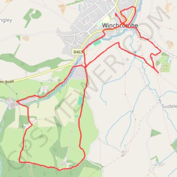
Name: Winchcombe GPS track, route, trail
Coordinates: 51.93335 -1.98817 51.95546 -1.95652
Other GPS tracks
Click on a GPS track to view route, its statistics and profile.
Dean2023-311
United Kingdom > England > Oxfordshire > Oxford
Distance: 192.8 mi • Elevation gain: 11,043 ft • Maximum elevation: 951 ft