Palm Ball Field and Nearby
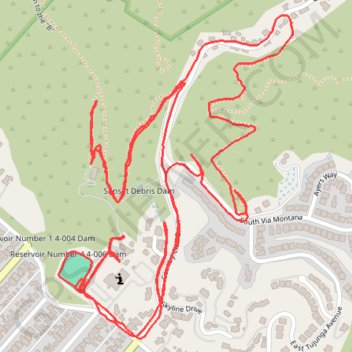
Loop hike in the Sunset Canyon. #Hike #Loop #Nature #Forest #Mountain #Canyon
- Distance: 3.7 mi
- Elevation gain: 879 ft
- Maximum elevation: 1,253 ft
- Elevation loss: 879 ft
- Minimum elevation: 896 ft
- Moving time: 1 h 36 m
- Moving speed: 2.3 mph
- Maximum speed: 4.5 mph
- Total time: 2 h 11 m
- Global speed: 1.7 mph
- Date: 02/14/2024
Interactive map
GPS track profile
About this GPS track
Name: Palm Ball Field and Nearby GPS track, route, trail
Coordinates: 34.19252 -118.29864 34.19986 -118.29225
Topography: Burbank topographic map
Other GPS tracks
Click on a GPS track to view route, its statistics and profile.
Verdugo Mountains Full Ridge
United States > California > Los Angeles
Hike on the Verdugo Mountains via Village Avenue Trail, La Tuna Peak, Chandler Mtrwy, Boy Scout Camp, Verdugo Motorway, Verdugo Crest Trail, Tree of Life, Wildhos Saddle, Verdugo Peak, Mesa Lila Road, Mount Thom and Las Flores Motorway. #Hike #Mountain #Nature #Forest #Park
Distance: 14.5 mi • Elevation gain: 3,852 ft • Maximum elevation: 3,104 ft