2024 4TUL Half Loop Final
- Distance: 55.3 mi
- Elevation gain: 7,438 ft
- Maximum elevation: 1,755 ft
- Elevation loss: 8,990 ft
- Minimum elevation: -3 ft
Interactive map
GPS track profile
About this GPS track
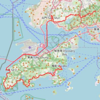
Name: 2024 4TUL Half Loop Final GPS track, route, trail
Coordinates: 22.20269 113.84347 22.40758 114.10636
Topography: Tsuen Wan District topographic map
Other GPS tracks
Click on a GPS track to view route, its statistics and profile.
深坑瀝小路
China > Hong Kong > Islands District > Luk Wu
Distance: 10.3 mi • Elevation gain: 2,382 ft • Maximum elevation: 1,516 ft
甲龍右 清潭
China > Hong Kong > Yuen Long District > Sheung Tsuen
Distance: 5.3 mi • Elevation gain: 1,414 ft • Maximum elevation: 1,565 ft
20240113Outdoor walk(1)
China > Hong Kong > Islands District > Ngong Ping Village
Distance: 2.5 mi • Elevation gain: 1,795 ft • Maximum elevation: 2,900 ft