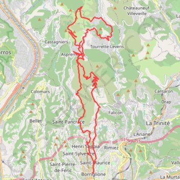
Mont Chauve mont Cima retour par plan d'Arriou
VTT. En boucle depuis Nice. #VTT #Boucle #Préalpes #Alpes #Montagne #Nature
- Distance: 25.7 mi
- Elevation gain: 5,846 ft
- Maximum elevation: 2,844 ft
- Elevation loss: 5,840 ft
- Minimum elevation: 118 ft
- Moving time: 3 h 59 m
- Moving speed: 6.4 mph
- Maximum speed: 27.0 mph
- Total time: 4 h 54 m
- Global speed: 5.2 mph
- Date: 03/24/2012
Interactive map
GPS track profile
About this GPS track
Name: Mont Chauve mont Cima retour par plan d'Arriou GPS track, route, trail
Coordinates: 43.71354 7.24070 43.81083 7.27670
Other GPS tracks
Click on a GPS track to view route, its statistics and profile.
La route des grandes Alpes
France > Auvergne-Rhône-Alpes > Haute-Savoie > Thonon-les-Bains
Distance: 425.1 mi • Elevation gain: 75,614 ft • Maximum elevation: 9,075 ft
Route-des-grandes-alpes-thonon-nice
France > Auvergne-Rhône-Alpes > Haute-Savoie > Thonon-les-Bains
Distance: 441.7 mi • Elevation gain: 78,386 ft • Maximum elevation: 9,075 ft
Route-des-grandes-alpes-thonon-nice
France > Auvergne-Rhône-Alpes > Haute-Savoie > Thonon-les-Bains
Distance: 441.7 mi • Elevation gain: 77,979 ft • Maximum elevation: 9,075 ft
GR®653A Via Aurelia (2023©gr-infos.com)
France > Provence-Alpes-Côte d'Azur > Alpes-Maritimes > Menton
Distance: 243.3 mi • Elevation gain: 28,435 ft • Maximum elevation: 2,598 ft
Traversée des Alpes de Modane à Nice
France > Auvergne-Rhône-Alpes > Savoie > Modane
Randonnée de montagne entre Modane et Nice. #Randonnée #Alpes #Montagne #Queyras #Mercantour #Méditerranée #Mer #Nature #GR5
Distance: 181.9 mi • Elevation gain: 57,287 ft • Maximum elevation: 8,766 ft
RGA
France > Auvergne-Rhône-Alpes > Haute-Savoie > Thonon-les-Bains
Distance: 439.8 mi • Elevation gain: 78,638 ft • Maximum elevation: 9,075 ft
Traversée des Alpes du lac Léman à la mer Méditerranée
France > Auvergne-Rhône-Alpes > Haute-Savoie > Saint-Gingolph
Au cœur d'une nature généreuse et variée, côtoyant les hauts sommets alpins mais aussi les hommes qui vivent ce massif au quotidien, le GR 5 Alpes ne vous laissera pas indifférent ! Osez l'aventure alpine et expérimentez la liberté ! #Randonnée #Alpes #Montagne #Mer #Méditerranée #Nature #Forêt #Lac #GR5
Distance: 319.2 mi • Elevation gain: 98,494 ft • Maximum elevation: 9,003 ft
HexaTrekGPX
France > Nouvelle-Aquitaine > Pyrénées-Atlantiques > Hendaye
Distance: 1,670.4 mi • Elevation gain: 452,047 ft • Maximum elevation: 9,675 ft
GR52 De Saint Dalmas de Valdeblore à Menton (Alpes-Maritimes)
France > Provence-Alpes-Côte d'Azur > Alpes-Maritimes > Valdeblore
Distance: 58.6 mi • Elevation gain: 21,188 ft • Maximum elevation: 8,832 ft
GR 51 - De Menton au Col de Testanier (Alpes Maritimes, Var)
France > Provence-Alpes-Côte d'Azur > Alpes-Maritimes > Menton
Distance: 121.1 mi • Elevation gain: 30,938 ft • Maximum elevation: 3,192 ft
Tour d'Europe
France > Bretagne > Finistère > Concarneau > Landan Creis
Distance: 4,432.2 mi • Elevation gain: 146,335 ft • Maximum elevation: 7,982 ft
GR 52 De Entraunes à Menton (Alpes-Maritimes) (2021)
France > Provence-Alpes-Côte d'Azur > Maritime Alps > Entraunes
Randonnée sur le GR 52 à travers les Alpes-Maritimes et le Parc National du Mercantour de Entraunes à Menton.
Distance: 138.5 mi • Elevation gain: 46,591 ft • Maximum elevation: 8,901 ft
Eurovelo 6
France > Pays de la Loire > Loire-Atlantique > Saint-Brevin-les-Pins
Distance: 2,815.0 mi • Elevation gain: 59,196 ft • Maximum elevation: 2,808 ft
Saint-Dalmas - Menton
France > Provence-Alpes-Côte d'Azur > Alpes-Maritimes > Valdeblore
Randonnée à travers le parc national du Mercantour et jusqu'à la Méditerranée entre Saint-Dalmas et Menton Garavan. #Randonnée #Mercantour #Argentera #Alpes #Montagne #Nature #Forêt #Mer #Méditerranée #GR52
Distance: 58.6 mi • Elevation gain: 21,204 ft • Maximum elevation: 8,832 ft
1-Dolomites-Le Pradet - Sondrio
France > Provence-Alpes-Côte d'Azur > Var > Le Pradet > Village du Pradet
Distance: 684.4 mi • Elevation gain: 95,463 ft • Maximum elevation: 9,072 ft
La route des grandes Alpes
France > Auvergne-Rhône-Alpes > Haute-Savoie > Cluses
Distance: 388.9 mi • Elevation gain: 70,436 ft • Maximum elevation: 9,075 ft
Nice Cyclisme sur route
France > Provence-Alpes-Côte d'Azur > Alpes-Maritimes > Nice
Distance: 24.4 mi • Elevation gain: 4,265 ft • Maximum elevation: 3,307 ft
P'tites Routes du Soleil
France > Auvergne-Rhône-Alpes > Haute-Savoie > Thonon-les-Bains
Distance: 563.2 mi • Elevation gain: 71,401 ft • Maximum elevation: 4,524 ft
GR 5 : De Grenoble à Nice
France > Auvergne-Rhône-Alpes > Isère > Échirolles
Distance: 226.9 mi • Elevation gain: 69,547 ft • Maximum elevation: 8,825 ft
GR51 De Menton (Alpes Maritimes) à La Madrague (Bouches-du-Rhône)
France > Provence-Alpes-Côte d'Azur > Alpes-Maritimes > Menton
Randonnée sur le GR51, Balcon de la Méditerranée, à travers les Alpes Maritimes, le Var et les Bouches-du-Rhône de Menton à La Madrague.
Distance: 345.2 mi • Elevation gain: 76,841 ft • Maximum elevation: 3,517 ft
GPSwerk-Tour/Track: Unbenannte Tour
France > Auvergne-Rhône-Alpes > Haute-Savoie > Thonon-les-Bains
Generated by GPSwerk. See www.gpswerk.de
Distance: 440.8 mi • Elevation gain: 76,873 ft • Maximum elevation: 9,075 ft
3-Misurina, Auronzo di Cadore - Le Pradet
Italie > Vénétie > Belluno > Auronzo di Cadore > Misurina
Distance: 686.2 mi • Elevation gain: 96,348 ft • Maximum elevation: 7,208 ft
RGA
France > Auvergne-Rhône-Alpes > Haute-Savoie > Thonon-les-Bains
Distance: 439.8 mi • Elevation gain: 79,104 ft • Maximum elevation: 9,075 ft
GR653A De Menton à Mandelieu-la-Napoule (Alpes-Maritimes)
France > Provence-Alpes-Côte d'Azur > Alpes-Maritimes > Menton
Randonnée sur le GR653A, Via Aurelia - Pèlerinage de Saint Jacques de Compostelle, à travers les Alpes-Maritimes de Menton à Mandelieu-la-Napoule via Roquebrune-Cap-Martin, La Gorra, Camp Bollin, Cantaron, Bordinas, Tourrette-Levens, Aspremont, Colomars, La Manda, Gattières, La Gaude, Vence, Tourrettes-sur-Loup, Le Colombier,…
Distance: 64.8 mi • Elevation gain: 12,431 ft • Maximum elevation: 2,598 ft
VoQjV
France > Auvergne-Rhône-Alpes > Haute-Savoie > Saint-Gingolph
Grande Traversée des Alpes de Saint-Gingolph à Nice
Distance: 332.6 mi • Elevation gain: 107,779 ft • Maximum elevation: 9,009 ft
Balcon de la Méditerranée de Menton au col de Testanier
France > Provence-Alpes-Côte d'Azur > Alpes-Maritimes > Menton
Randonnée à travers le littoral méditerranéen, le parc naturel régional des Préalpes d'Azur et le massif de l'Esterel entre Menton et le col de Testanier près du mont Vinaigre. #Randonnée #Mer #Méditerranée #Préalpes #Esterel #Nature #Montagne #Forêt #GR51
Distance: 121.1 mi • Elevation gain: 30,935 ft • Maximum elevation: 3,192 ft
Baroudeuse_650km
France > Provence-Alpes-Côte d'Azur > Alpes-Maritimes > Nice
Distance: 446.3 mi • Elevation gain: 85,873 ft • Maximum elevation: 9,364 ft
Traversée des Alpes
France > Auvergne-Rhône-Alpes > Haute-Savoie > Sallenôves > Bonlieu
Distance: 366.1 mi • Elevation gain: 62,044 ft • Maximum elevation: 9,075 ft
Mon parcours
France > Nouvelle-Aquitaine > Pyrénées-Atlantiques > Hendaye
Total: 896.1km
Distance: 556.1 mi • Elevation gain: 26,860 ft • Maximum elevation: 1,614 ft
1 LUCENA - MONTPELLIER
Distance: 1,842.0 mi • Elevation gain: 96,785 ft • Maximum elevation: 3,438 ft
1 LUCENA - MONTPELLIER
Espagne > Andalousie > Lucena
Distance: 1,842.0 mi • Elevation gain: 96,785 ft • Maximum elevation: 3,438 ft
GPSwerk-Tour/Track: Unbenannte Tour
France > Auvergne-Rhône-Alpes > Haute-Savoie > Thonon-les-Bains
Generated by GPSwerk. See www.gpswerk.de
Distance: 440.8 mi • Elevation gain: 76,873 ft • Maximum elevation: 9,075 ft
6 Saint-martin-vesubie-Menton
France > Provence-Alpes-Côte d'Azur > Alpes-Maritimes > Saint-Martin-Vésubie
Distance: 45.9 mi • Elevation gain: 10,246 ft • Maximum elevation: 5,279 ft
SJCF-Nice 20K 07.07.23
France > Provence-Alpes-Côte d'Azur > Alpes-Maritimes > Saint-Jean-Cap-Ferrat
Distance: 13.8 mi • Elevation gain: 2,913 ft • Maximum elevation: 1,263 ft
Saint-Dalmas - Menton Garavan
France > Provence-Alpes-Côte d'Azur > Alpes-Maritimes > Valdeblore
Randonnée du parc national du Mercantour à la mer Méditerranée entre Saint-Dalmas et Menton Garavan. #Randonnée #Montagne #Alpes #Mercantour #Mer #Méditerranée #Nature #Forêt #GR52
Distance: 59.8 mi • Elevation gain: 21,686 ft • Maximum elevation: 8,835 ft
GR653A De Menton à Mandelieu-la-Napoule (Alpes-Maritimes) (2019)
France > Provence-Alpes-Côte d'Azur > Alpes-Maritimes > Menton
Randonnée sur le GR653A à travers les Alpes-Maritimes de Menton à Mandelieu-la-Napoule.
Distance: 64.1 mi • Elevation gain: 12,395 ft • Maximum elevation: 2,598 ft
RGA
France > Auvergne-Rhône-Alpes > Haute-Savoie > Thonon-les-Bains
Distance: 439.8 mi • Elevation gain: 79,104 ft • Maximum elevation: 9,075 ft
De Giromagny à Sofia
France > Bourgogne-Franche-Comté > Territoire-de-Belfort > Giromagny
Distance: 1,165.7 mi • Elevation gain: 39,724 ft • Maximum elevation: 3,458 ft
FRANCE REAL GPX
Espagne > Catalogne > Ripollais > Toses
Distance: 683.5 mi • Elevation gain: 107,700 ft • Maximum elevation: 8,720 ft