吊燈籠
- Distance: 5.1 mi
- Elevation gain: 1,378 ft
- Maximum elevation: 1,234 ft
- Elevation loss: 1,378 ft
- Minimum elevation: 157 ft
- Moving time: 3 h 35 m
- Moving speed: 1.4 mph
- Maximum speed: 3.2 mph
- Total time: 5 h 24 m
- Global speed: 0.9 mph
- Date: 03/03/2024
Interactive map
GPS track profile
About this GPS track
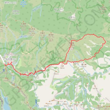
Name: 吊燈籠 GPS track, route, trail
Coordinates: 22.50297 114.24171 22.51293 114.26784
Other GPS tracks
Click on a GPS track to view route, its statistics and profile.
Wilson Trail Full Route
China > Hong Kong > Hong Kong Island
Distance: 50.5 mi • Elevation gain: 14,534 ft • Maximum elevation: 2,011 ft