Mount Islip
Interactive map
GPS track profile
About this GPS track
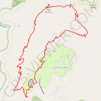
Name: Mount Islip GPS track, route, trail
Coordinates: 34.31444 -117.85405 34.34543 -117.82417
Topography: Los Angeles County topographic map
Other GPS tracks
Click on a GPS track to view route, its statistics and profile.
South Mount Hawkins, Sadie Hawkins and Middle Hawkins Loop
United States > California > Crystal Lake
Loop hike from Crystal Lake Campground to South Mount Hawkins, Sadie Hawkins and Middle Hawkins via Windy Gap Trail, Hawkins Ridge Trail, Pacific Crest Trail (PCT) / Silver Mocasin Trail and Windy Gap in the San Gabriel Wilderness and the Angeles National Forest. #Hike #Loop #Mountain #Nature #Forest #Wilderness #PCT
Distance: 11.4 mi • Elevation gain: 3,845 ft • Maximum elevation: 8,432 ft