Salt Mountain Loop
- Distance: 2.5 mi
- Elevation gain: 892 ft
- Maximum elevation: 758 ft
- Elevation loss: 896 ft
- Minimum elevation: 72 ft
- Moving time: 1 h 32 m
- Moving speed: 1.7 mph
- Maximum speed: 4.0 mph
- Total time: 2 h 27 m
- Global speed: 1.0 mph
- Date: 04/30/2024
Interactive map
GPS track profile
About this GPS track
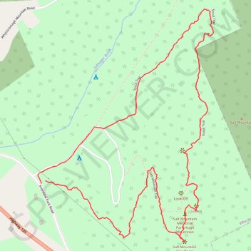
Name: Salt Mountain Loop GPS track, route, trail
Coordinates: 45.96386 -61.10433 45.97344 -61.09392
Other GPS tracks
Click on a GPS track to view route, its statistics and profile.
Antigonish - Whycocomagh
Canada > Nova Scotia > Town of Antigonish > Antigonish
Gulf of Saint Lawrence. Cape Breton Island. #Bike #Antigonish #Whycocomagh #SaintLawrence #CapeBreton
Distance: 64.6 mi • Elevation gain: 2,923 ft • Maximum elevation: 443 ft