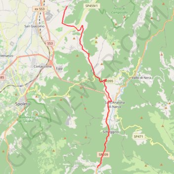
De Ceselli à Poreta
Randonnée entre Ceselli et Poreta. #Randonnée
- Distance: 11.8 mi
- Elevation gain: 2,067 ft
- Maximum elevation: 2,425 ft
- Elevation loss: 1,946 ft
- Minimum elevation: 906 ft
Interactive map
GPS track profile
About this GPS track
Name: De Ceselli à Poreta GPS track, route, trail
Start: Via di Spoleto, Ceselli, Scheggino, Perugia, Ombrie, 06040, Italie (42.68465 12.81727)
Coordinates: 42.68465 12.78051 42.80966 12.83255
Other GPS tracks
Click on a GPS track to view route, its statistics and profile.
Tour d'Europe
France > Bretagne > Finistère > Concarneau > Landan Creis
Distance: 4,432.2 mi • Elevation gain: 146,335 ft • Maximum elevation: 7,982 ft
Percorso selezionato
Italie > Lombardie > Côme > Côme
Percorso calcolato con http://www.bicitalia.org/it/routing-gpx
Distance: 959.4 mi • Elevation gain: 58,894 ft • Maximum elevation: 3,392 ft
De Giromagny à Sofia
France > Bourgogne-Franche-Comté > Territoire-de-Belfort > Giromagny
Distance: 1,165.7 mi • Elevation gain: 39,724 ft • Maximum elevation: 3,458 ft