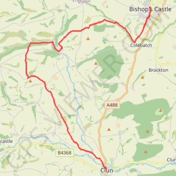
Bishops Castle to Clun
- Distance: 12.9 mi
- Elevation gain: 1,988 ft
- Maximum elevation: 1,322 ft
- Elevation loss: 2,014 ft
- Minimum elevation: 587 ft
- Moving time: 5 h 49 m
- Moving speed: 2.2 mph
- Maximum speed: 3.8 mph
- Total time: 6 h 58 m
- Global speed: 1.8 mph
- Date: 04/20/2024
Interactive map
GPS track profile
About this GPS track
Name: Bishops Castle to Clun GPS track, route, trail
End: The White Horse, The Square, Clun, Shropshire, England, SY7 8JA, United Kingdom (52.42144 -3.03018)
Coordinates: 52.42144 -3.09005 52.49452 -2.99774
Other GPS tracks
Click on a GPS track to view route, its statistics and profile.
Clun to Craven Arms
United Kingdom > England > Shropshire > Clun
Distance: 11.8 mi • Elevation gain: 1,608 ft • Maximum elevation: 1,283 ft
TT22 J9 M7/06 : Heysham Port à Aberystwyth
Royaume-Uni > Angleterre > Lancashire > Lancaster > Morecambe
Distance: 215.9 mi • Elevation gain: 13,264 ft • Maximum elevation: 1,375 ft