Corinth Reservoir
- Distance: 4.3 mi
- Elevation gain: 676 ft
- Maximum elevation: 1,306 ft
- Elevation loss: 679 ft
- Minimum elevation: 830 ft
- Moving time: 1 h 42 m
- Moving speed: 2.5 mph
- Maximum speed: 8.5 mph
- Total time: 1 h 47 m
- Global speed: 2.4 mph
- Date: 04/23/2024
Interactive map
GPS track profile
About this GPS track
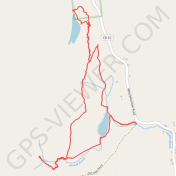
Name: Corinth Reservoir GPS track, route, trail
Start: Old Town Road, Town of Corinth, Saratoga County, New York, 12822, United States (43.25060 -73.86259)
End: Old Town Road, Town of Corinth, Saratoga County, New York, 12822, United States (43.25058 -73.86234)
Coordinates: 43.24603 -73.87571 43.26219 -73.86234
Topography: Saratoga County topographic map
Other GPS tracks
Click on a GPS track to view route, its statistics and profile.
Montréal - New York
Canada > Québec > Agglomération de Montréal > Montréal
Distance: 396.0 mi • Elevation gain: 13,563 ft • Maximum elevation: 988 ft
Niagara - Albany
États-Unis d'Amérique > New York > Niagara County > City of Niagara Falls
Distance: 334.3 mi • Elevation gain: 7,910 ft • Maximum elevation: 650 ft