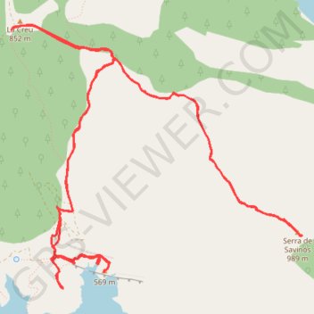
Trace-Gps-Sabinos-et-Finestras-2016-05-05
- Distance: 9.2 mi
- Elevation gain: 2,047 ft
- Maximum elevation: 3,225 ft
- Elevation loss: 2,051 ft
- Minimum elevation: 1,677 ft
- Moving time: 3 h 49 m
- Moving speed: 2.4 mph
- Maximum speed: 3.7 mph
- Total time: 5 h 45 m
- Global speed: 1.6 mph
- Date: 05/05/2016
Interactive map
GPS track profile
About this GPS track
Name: Trace-Gps-Sabinos-et-Finestras-2016-05-05 GPS track, route, trail
Start: Cruz, Viacamp y Litera/Viacamp i Lliterà, Ribagorce, Huesca, Aragon, Espagne (42.02682 0.61327)
End: Cruz, Viacamp y Litera/Viacamp i Lliterà, Ribagorce, Huesca, Aragon, Espagne (42.02660 0.61305)
Coordinates: 42.00433 0.61305 42.02709 0.64667
Other GPS tracks
Click on a GPS track to view route, its statistics and profile.
Southern section — European Divide Trail
France > Auvergne-Rhône-Alpes > Drôme > Valence
Distance: 1,506.1 mi • Elevation gain: 139,026 ft • Maximum elevation: 6,578 ft
Bardenas_Andorre_Mediterranee
Bardenas_Andorre_Mediterranee
Distance: 628.2 mi • Elevation gain: 80,394 ft • Maximum elevation: 7,264 ft
1 LUCENA - MONTPELLIER
Distance: 1,842.0 mi • Elevation gain: 96,785 ft • Maximum elevation: 3,438 ft
1 LUCENA - MONTPELLIER
Espagne > Andalousie > Lucena
Distance: 1,842.0 mi • Elevation gain: 96,785 ft • Maximum elevation: 3,438 ft
Stage 26: Valence to Saint-Jean-de-Fos — European Divide Trail
France > Auvergne-Rhône-Alpes > Drôme > Valence
Distance: 1,506.1 mi • Elevation gain: 139,026 ft • Maximum elevation: 6,578 ft
Stage 26: Valence to Saint-Jean-de-Fos — European Divide Trail
France > Auvergne-Rhône-Alpes > Drôme > Valence
Distance: 1,012.7 mi • Elevation gain: 101,184 ft • Maximum elevation: 6,578 ft
De Villeneuve-sur-Lot à Guimarães
France > Nouvelle-Aquitaine > Lot-et-Garonne > Villeneuve-sur-Lot
Distance: 1,257.8 mi • Elevation gain: 72,575 ft • Maximum elevation: 4,393 ft