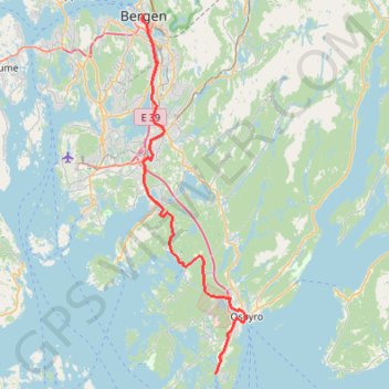
001: Bergen – Halhjem (Developed with signs)
Developed with signs
- Distance: 24.5 mi
- Elevation gain: 1,394 ft
- Maximum elevation: 715 ft
- Elevation loss: 1,407 ft
- Minimum elevation: 0 ft
Interactive map
GPS track profile
About this GPS track
Name: 001: Bergen – Halhjem (Developed with signs) GPS track, route, trail
End: Halhjem, Halhjemsvegen, Auredalen, Haljem, Bjørnafjorden, Vestland, 5208, Norvège (60.14558 5.42642)
Coordinates: 60.14558 5.32469 60.39474 5.46915
Other GPS tracks
Click on a GPS track to view route, its statistics and profile.
001: Bergen – Halhjem (DEVELOPED_WITH_SIGNS)
DEVELOPED_WITH_SIGNS
Distance: 25.9 mi • Elevation gain: 2,313 ft • Maximum elevation: 758 ft
001: Bergen – Halhjem (Developed with signs)
Developed with signs
Distance: 25.6 mi • Elevation gain: 2,070 ft • Maximum elevation: 741 ft