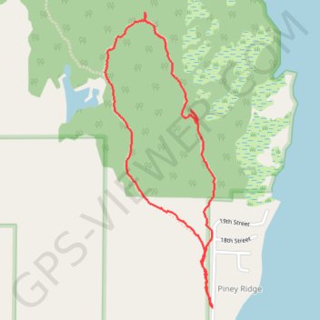
Ludington Park Loop
Loop hike in the Ludington State Park from Piney Ridge by the Hamlin Lake. #Hike #Loop #Forest #Nature #Park #Lake
- Distance: 2.2 mi
- Elevation gain: 105 ft
- Maximum elevation: 669 ft
- Elevation loss: 102 ft
- Minimum elevation: 617 ft
- Moving time: 54 m 16 s
- Moving speed: 2.4 mph
- Maximum speed: 11.9 mph
- Total time: 55 m 38 s
- Global speed: 2.3 mph
- Date: 02/22/2024
Interactive map
GPS track profile
About this GPS track
Name: Ludington Park Loop GPS track, route, trail
Coordinates: 44.01446 -86.47955 44.02685 -86.47317
Topography: Mason County topographic map