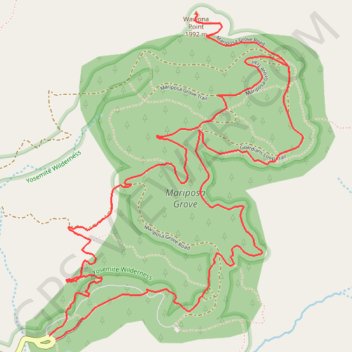
Wawona Point (Mariposa Grove)
Loop hike through Mariposa Grove to Wawona Point via Big Trees Trail, Fallen Monarch, Bachelor and Three Graces, Grizzly Giant, California Tunnel Tree, Telescope Tree, Fallen Tunnel Tree, Columbia Tree, Clothespin Tree and Faithful Couple Tree In Yosemite National Park. #Hike #Loop #Mountain #Forest #Nature #Park #Yosemite
- Distance: 6.4 mi
- Elevation gain: 1,345 ft
- Maximum elevation: 6,759 ft
- Elevation loss: 1,342 ft
- Minimum elevation: 5,663 ft
Interactive map
GPS track profile
About this GPS track
Name: Wawona Point (Mariposa Grove) GPS track, route, trail
Start: Grove Arrival Area, Mariposa County, California, United States (37.50145 -119.61057)
End: Grove Arrival Area, Mariposa County, California, United States (37.50163 -119.61100)
Coordinates: 37.50145 -119.61100 37.51888 -119.59392
Topography: Mariposa County topographic map
Other GPS tracks
Click on a GPS track to view route, its statistics and profile.
Walker - Auberry
États-Unis d'Amérique > Californie > Mono County > Walker
Vélo. En aller simple entre Walker et Auberry. #Vélo
Distance: 220.0 mi • Elevation gain: 21,762 ft • Maximum elevation: 9,970 ft