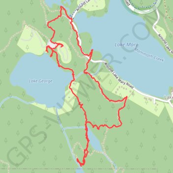
Mammoth Lakes Loop
Loop hike via Lake Mary, Lake Barret, T J Lake, Lake George, Lake Mamie and Mammoth Creek in the Inyo National Forest. #Hike #Loop #Lake #Forest #Nature #River #Mountain
- Distance: 3.3 mi
- Elevation gain: 522 ft
- Maximum elevation: 9,324 ft
- Elevation loss: 512 ft
- Minimum elevation: 8,907 ft
- Moving time: 1 h 18 m
- Moving speed: 2.6 mph
- Maximum speed: 22.8 mph
- Total time: 1 h 39 m
- Global speed: 2.0 mph
- Date: 07/27/2018
Interactive map
GPS track profile
About this GPS track
Name: Mammoth Lakes Loop GPS track, route, trail
Coordinates: 37.59359 -119.01148 37.60622 -119.00340
Topography: Mono County topographic map
Other GPS tracks
Click on a GPS track to view route, its statistics and profile.
JMT1-16847633
États-Unis d'Amérique > Californie > Inyo County
Distance: 249.4 mi • Elevation gain: 49,836 ft • Maximum elevation: 14,386 ft