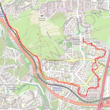
Zeopoxa Cycling
- Distance: 6.7 mi
- Elevation gain: 515 ft
- Maximum elevation: 673 ft
- Elevation loss: 509 ft
- Minimum elevation: 394 ft
- Moving time: 1 h 15 m
- Moving speed: 5.3 mph
- Maximum speed: 12.8 mph
- Total time: 1 h 18 m
- Global speed: 5.2 mph
- Date: 09/15/2020
Interactive map
GPS track profile
About this GPS track
Name: Zeopoxa Cycling GPS track, route, trail
Start: Rua Padeira de Aljubarrota, Queluz e Belas, Sintra, Lisbon, 2745-877, Portugal (38.76095 -9.27743)
End: Rua Padeira de Aljubarrota, Queluz e Belas, Sintra, Lisbon, 2745-877, Portugal (38.76123 -9.27776)
Coordinates: 38.74924 -9.29812 38.76631 -9.27180
Topography: Lisbon topographic map
Other GPS tracks
Click on a GPS track to view route, its statistics and profile.
Eurovelo 01 Spain + Portugal
France > Nouvelle-Aquitaine > Pyrénées-Atlantiques > Hendaye
Distance: 1,930.7 mi • Elevation gain: 100,367 ft • Maximum elevation: 4,931 ft
EuroVelo 1 (Por
Portugal > Viana do Castelo > Caminha > Terreiro
Distance: 718.6 mi • Elevation gain: 35,509 ft • Maximum elevation: 833 ft
01: Lisboa – Azenhas do Mar (Developed)
Portugal > Lisbonne > Lisbonne
Developed
Distance: 34.3 mi • Elevation gain: 1,942 ft • Maximum elevation: 833 ft