Old Ilchester Quarry Scouting
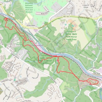
Patapsco Valley State Park - Morning Hike
- Distance: 5.2 mi
- Elevation gain: 958 ft
- Maximum elevation: 354 ft
- Elevation loss: 951 ft
- Minimum elevation: 135 ft
- Moving time: 2 h 31 m
- Moving speed: 2.0 mph
- Maximum speed: 5.7 mph
- Total time: 3 h 4 m
- Global speed: 1.7 mph
Interactive map
GPS track profile
About this GPS track
Name: Old Ilchester Quarry Scouting GPS track, route, trail
Coordinates: 39.25007 -76.79247 39.26474 -76.76558
Topography: Howard County topographic map, elevation, terrain
Other GPS tracks
Click on a GPS track to view its route, statistics and profile.
St. Mary’s College and Chapel Ruins Loop in Patapsco Valley State Park Ilchester Area
United States > Maryland > Howard County > Ilchester
The St. Mary’s College and Chapel Ruins Loop offers hikers a unique blend of nature and history, showcasing the remnants of a once-grand seminary that dates back to the late 19th century. As you walk along the trail, you’ll encounter intriguing ruins, including stone remnants and a striking metal cross,…
Distance: 2.1 mi • Elevation gain: 269 ft • Maximum elevation: 381 ft
Hike through Patapsco Valley State Park Ilchester Area
United States > Maryland > Howard County > Ilchester
Distance: 5.3 mi • Elevation gain: 915 ft • Maximum elevation: 354 ft
Crossing Patapsco Valley State Park Ilchester Area
United States > Maryland > Howard County > Ilchester
Morning Hike
Distance: 3.6 mi • Elevation gain: 738 ft • Maximum elevation: 361 ft
Patapsco Valley State Park Ilchester Area
United States > Maryland > Howard County > Ilchester
Morning Hike
Distance: 4.5 mi • Elevation gain: 705 ft • Maximum elevation: 354 ft
Patapsco Valley State Park
United States > Maryland > Baltimore County > Catonsville
Morning Loop Hike
Distance: 6.1 mi • Elevation gain: 1,050 ft • Maximum elevation: 410 ft
Morning Hike
United States > Maryland > Baltimore County > Catonsville
Distance: 5.9 mi • Elevation gain: 732 ft • Maximum elevation: 404 ft
Scouting Old Ilchester
United States > Maryland > Howard County > Ilchester
Morning Hike
Distance: 4.9 mi • Elevation gain: 735 ft • Maximum elevation: 354 ft
Scouting Old Ilchester
United States > Maryland > Howard County > Ilchester
Morning Hike
Distance: 4.9 mi • Elevation gain: 837 ft • Maximum elevation: 354 ft
Patapsco Valley State Park Ilchester Area
United States > Maryland > Howard County > Ilchester
Morning Hike
Distance: 4.8 mi • Elevation gain: 856 ft • Maximum elevation: 358 ft