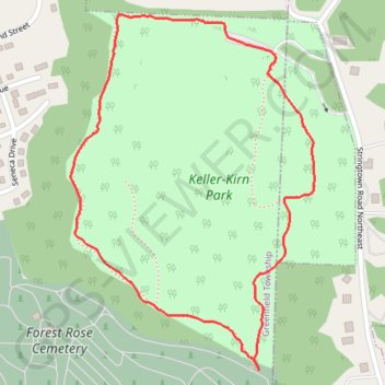
Keller Kirn outer loop trail (with entrance from cemetery)
- Distance: 1.3 mi
- Elevation gain: 164 ft
- Maximum elevation: 1,142 ft
- Elevation loss: 164 ft
- Minimum elevation: 1,004 ft
- Moving time: 24 m 19 s
- Moving speed: 3.3 mph
- Maximum speed: 9.9 mph
- Total time: 24 m 54 s
- Global speed: 3.2 mph
- Date: 04/14/2024
Interactive map
GPS track profile
About this GPS track
Name: Keller Kirn outer loop trail (with entrance from cemetery) GPS track, route, trail
Coordinates: 39.73211 -82.60479 39.73874 -82.59889
Topography: Lancaster topographic map