Atlanta Critical Mass
- Distance: 14.5 mi
- Elevation gain: 1,096 ft
- Maximum elevation: 1,122 ft
- Elevation loss: 1,106 ft
- Minimum elevation: 863 ft
- Moving time: 1 h 47 m
- Moving speed: 8.1 mph
- Maximum speed: 23.0 mph
- Total time: 2 h 4 m
- Global speed: 7.0 mph
- Date: 09/29/2023
Interactive map
GPS track profile
About this GPS track
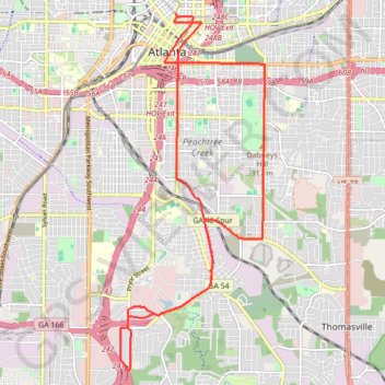
Name: Atlanta Critical Mass GPS track, route, trail
Coordinates: 33.68905 -84.40075 33.75602 -84.36812
Topography: Atlanta topographic map
Other GPS tracks
Click on a GPS track to view route, its statistics and profile.
Atlanta Critical Mass bike ride
United States > Georgia > Fulton County > Atlanta
Distance: 8.8 mi • Elevation gain: 679 ft • Maximum elevation: 1,184 ft
The Atlanta Donut Ride
United States > Georgia > Fulton County > Atlanta
Distance: 10.2 mi • Elevation gain: 778 ft • Maximum elevation: 1,155 ft